Leave less behind.
Prevent avoidable breakups. Release stored energy and make the end of a mission part of its design.
Satellites provide communications, navigation and observations of Earth. When missions end, spacecraft and debris can remain in orbit.
Explore the orbitsFrom the ground, the sky can feel impossibly empty. From orbit, it is a place we work, build and leave things behind.
Weather and communications satellites share orbital regions with retired spacecraft, spent rocket stages and fragments.
ESA · Types of orbits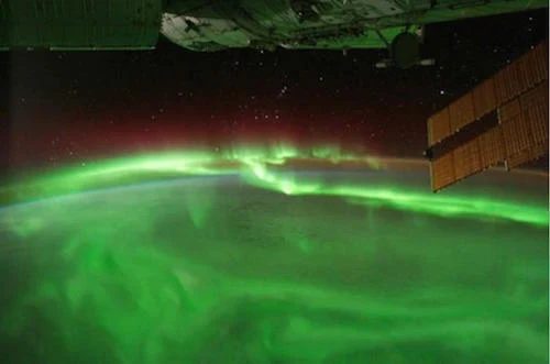
Altitude changes the view—and the job.
Move outward through three orbital regions. Then reveal what shares the space.
Close enough to see the detail. Earth observation, crewed missions and many communications satellites work close to home. A low orbit sweeps across a changing landscape below.
Try adding debris. Symbols show the idea, not actual positions or population ratios. Distances are compressed so you can explore the full range of altitudes.
Watch the boundary between day and night lean through the seasons. A distant spacecraft turns a whole planet into an observation.
26 seconds · silent time-lapse · press play
NASA Earth Observatory · Follow the LineA retired satellite. A spent rocket stage. Fragments from a breakup. Once the work is done, the material can remain.
And the objects we can track are only part of the picture.
Objects regularly tracked by surveillance networks. This total includes working spacecraft as well as debris.
ESA · Space environment statisticsTracked total: July 2026. Size-band estimates: ESA MASTER-8, February 2026 population. The categories use different methods; they are not slices of one measured total. Fragment illustrations are enlarged.
functioning satellites in ESA’s July 2026 update.
The infrastructure worth protecting.
On 10 February 2009, the working Iridium 33 satellite collided with the defunct Cosmos 2251 over Siberia. Their fragments entered orbits of their own.
Play or scrub the sequence. Time, trajectories and fragment count are illustrative. This is not a collision prediction or a physics simulation.
Debris does not simply stop when a mission does. Atmospheric drag gradually brings some objects down. At higher altitudes, debris can remain for much longer. Each surviving fragment can become part of another close encounter.
Why orbital lifetime mattersDebris mitigation includes preventing breakups and planning disposal before launch. Removing existing debris presents a separate technical challenge.
Prevent avoidable breakups. Release stored energy and make the end of a mission part of its design.
Make disposal part of the mission: reentry where appropriate, or movement away from heavily used orbital regions.
Preventing new debris is essential. Research into removing existing objects tackles the material already in orbit.
Space feels infinite.
The places we use are not.
ESA reference figures are a fixed edition, updated 31 July 2026; model estimates refer to February 2026. The opening globe and altitude explainer use Natural Earth land geometry and synthetic circular orbits. Their dots are illustrative, enlarged and not proportional to population counts; those two diagrams do not show measured satellite positions. Orbital distances are compressed to keep all regions visible. Altitude is measured above Earth's surface. The collision sequence compresses time and illustrates fragmentation, not the actual trajectories or fragment count of the 2009 event. The satellite atlas adds a separate, dated CelesTrak active-group snapshot, with SGP4-calculated subpoints and ground tracks. Its local download includes element epochs, source metadata and excluded-record counts; it is not live telemetry or a complete debris inventory. The reference-figure download has null geometry because global counts have no geographic point location.
Snapshot updated 31 July 2026. Small-debris estimates use MASTER-8, reference population February 2026; these are not a live count.
Orbital regions, altitude and satellite applications.
10 February 2009; approximately 790 km altitude; relative speed 11.6 km/s. The animation is an explanation, not a reconstruction.
Debris hazards, atmospheric drag and orbital lifetimes.
Preventing breakups, end-of-life disposal and the Zero Debris approach.
NASA photograph: aurora over the southern Indian Ocean, 17 September 2011. Locally hosted image; cropped for presentation.
Silent satellite time-lapse, released 31 October 2013. Robert Simmon; Meteosat-9 imagery from EUMETSAT. Locally hosted video.
Public-domain coastlines used for the globe. Original orbital illustrations by Atlas.
Active-group orbital elements in OMM-compatible JSON. The satellite atlas displays a locally stored, dated edition, with calculated positions using satellite.js / SGP4.
Refresh no more than once per two-hour GP update; stop on non-200 responses. Readers load a locally hosted edition.
Editorial edition · 13 September 2026. Data and media retain their individual reference dates.