All storiesOur changing planet · 5 min read Download data
Skip to story content

Our changing planet

A restless planet

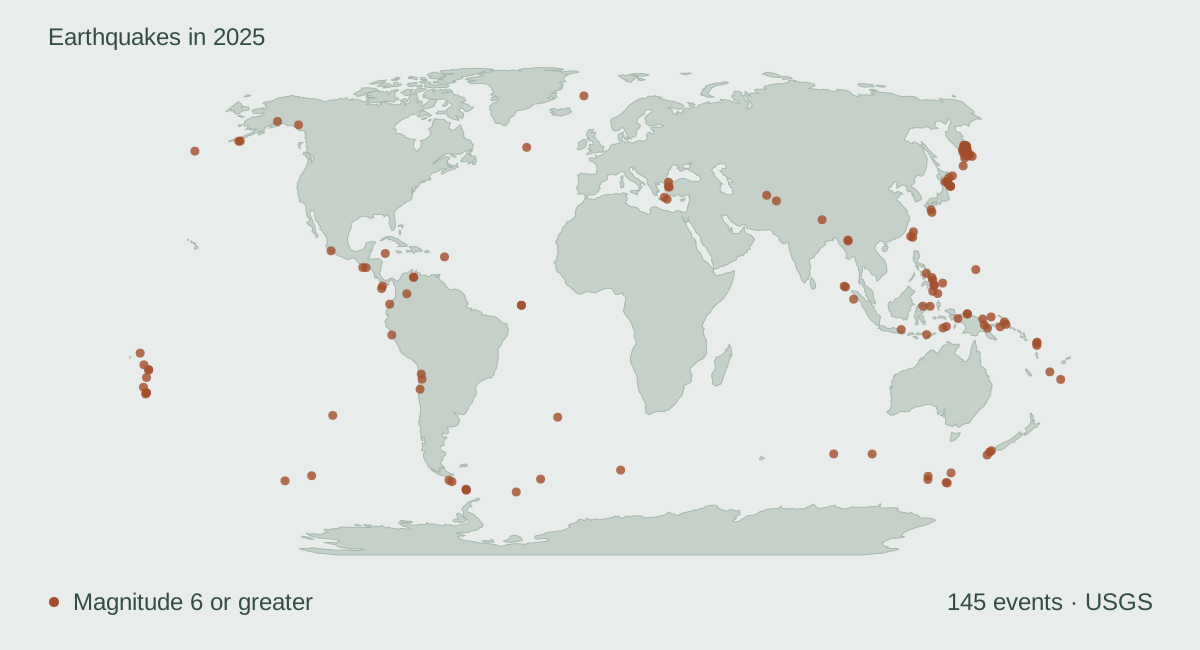
Map 145 earthquakes of magnitude 6 or greater recorded in 2025. Compare their depths and replay the year.

Sources: USGS

Start reading ↓
World map showing the locations of 145 earthquakes of magnitude 6 or greater in 2025.
USGS · 2025 catalog snapshot

Earthquakes recorded in 2025

A dot on a map gives an earthquake a place. Add time and depth, and a different planet emerges.

Replay 145 magnitude 6+ earthquakes from 2025. Look for the deep events: they are not always the biggest circles. Then follow four observations into the landscape.

Location, magnitude and depth

Replay the year, rotate the globe, or locate an event. The same observations appear on the globe and in the depth plot.

Earthquake catalog · 2025145 OF 145 EVENTS

Start with the largest event, compare a deep earthquake, or replay the year below.

2025 Southern Tibetan Plateau Earthquake · M7.1 · 10 km deep15 km SE of Miyazaki, Japan · M6.8 · 39 km deep10 km NE of Yujing, Taiwan · M6 · 16 km deep85 km SE of Lata, Solomon Islands · M6 · 36 km deep45 km E of Modisi, Indonesia · M6.1 · 21.726 km deepNicobar Islands, India region · M6 · 23 km deep88 km SSE of Adak, Alaska · M6.2 · 17 km deep170 km WSW of Riverton, New Zealand · M6.7 · 21 km deep2025 Mandalay, Burma (Myanmar) Earthquake · M7.7 · 10 km deepBurma (Myanmar) · M6.7 · 10 km deep61 km SSE of Pangai, Tonga · M7 · 29 km deep72 km SSE of Pangai, Tonga · M6.2 · 17 km deepPacific-Antarctic Ridge · M6.3 · 10 km deep56 km ENE of Nishinoomote, Japan · M6.1 · 29 km deep184 km ESE of Kimbe, Papua New Guinea · M6.9 · 9 km deep104 km ESE of Kokopo, Papua New Guinea · M6.1 · 52 km deepsouth of the Fiji Islands · M6.5 · 271 km deepsoutheast Indian Ridge · M6.6 · 10 km deep271 km SE of Pondaguitan, Philippines · M6.2 · 104 km deep285 km SW of Bluff, New Zealand · M6.2 · 10.595 km deepMacquarie Island region · M6.8 · 18.957 km deep142 km W of Neiafu, Tonga · M6.4 · 260 km deep89 km ENE of Angoram, Papua New Guinea · M6.5 · 16.819 km deepwest of Macquarie Island · M6.1 · 10 km deep187 km SSW of ‘Ohonua, Tonga · M6 · 48 km deep78 km S of Kushiro, Japan · M6 · 21 km deepKermadec Islands region · M6.1 · 10 km deepKermadec Islands region · M6 · 10 km deepKermadec Islands region · M6.2 · 10 km deepwestern Indian-Antarctic Ridge · M6.2 · 10 km deepKuril Islands · M6 · 35 km deep82 km SE of Nemuro, Japan · M6 · 18 km deepeast of the Philippine Islands · M6.2 · 10 km deep65 km E of Sarangani, Philippines · M6 · 99.77 km deep213 km WSW of Riverton, New Zealand · M6.2 · 22 km deep180 km WSW of Tual, Indonesia · M6.7 · 70.687 km deep2025 Sand Point, Alaska Earthquake · M7.3 · 38 km deep134 km E of Petropavlovsk-Kamchatsky, Russia · M6.6 · 23 km deep2025 Eastern Kamchatka, Russia Earthquake · M7.4 · 34 km deep153 km ESE of Petropavlovsk-Kamchatsky, Russia · M6.6 · 10 km deep143 km E of Petropavlovsk-Kamchatsky, Russia · M6.5 · 34.991 km deep91 km SSE of Sand Point, Alaska · M6.2 · 40 km deep154 km ESE of Petropavlovsk-Kamchatsky, Russia · M6 · 12.308 km deep109 km W of Gorontalo, Indonesia · M6.3 · 142 km deep163 km E of Petropavlovsk-Kamchatsky, Russia · M6 · 14 km deep187 km SSE of Mata-Utu, Wallis and Futuna · M6.6 · 314.151 km deepwest of Macquarie Island · M6.2 · 10 km deepMacquarie Island region · M6.2 · 17 km deep264 km WNW of Sabang, Indonesia · M6.4 · 21 km deepMacquarie Island region · M7 · 31 km deepsouth of the Fiji Islands · M6.6 · 553 km deep2025 Kamchatka Peninsula, Russia Earthquake · M8.8 · 35 km deep94 km SE of Petropavlovsk-Kamchatsky, Russia · M6.3 · 16.375 km deep78 km SE of Petropavlovsk-Kamchatsky, Russia · M6.1 · 25.423 km deep124 km ENE of Ozernovskiy, Russia · M6 · 35 km deep165 km SSE of Vilyuchinsk, Russia · M6 · 35 km deep125 km SE of Petropavlovsk-Kamchatsky, Russia · M6.9 · 36.622 km deep126 km SE of Vilyuchinsk, Russia · M6.2 · 35 km deep183 km SE of Vilyuchinsk, Russia · M6.1 · 10.445 km deep138 km SE of Severo-Kuril’sk, Russia · M6 · 35 km deep222 km SE of Severo-Kuril’sk, Russia · M6.2 · 15 km deep215 km ESE of Severo-Kuril’sk, Russia · M6.1 · 10 km deep165 km SSE of Vilyuchinsk, Russia · M6 · 17 km deep123 km E of Severo-Kuril’sk, Russia · M6.8 · 30 km deep202 km S of Severo-Kuril’sk, Russia · M6.2 · 16 km deep265 km ESE of Severo-Kuril’sk, Russia · M6 · 11 km deep195 km WNW of Abepura, Indonesia · M6.3 · 14 km deep115 km SSE of Lata, Solomon Islands · M6.3 · 44.99 km deepeast of the Kuril Islands · M6.1 · 9 km deep92 km E of Severo-Kuril’sk, Russia · M6 · 40 km deep35 km WSW of Asadābād, Afghanistan · M6 · 8 km deepVanuatu region · M6.4 · 10 km deep105 km E of Petropavlovsk-Kamchatsky, Russia · M7.4 · 58 km deep144 km ESE of Petropavlovsk-Kamchatsky, Russia · M6 · 15 km deep208 km SE of Kokopo, Papua New Guinea · M6 · 31 km deep26 km S of Nabire, Indonesia · M6 · 28 km deep140 km E of Petropavlovsk-Kamchatsky, Russia · M7.8 · 27 km deep98 km ESE of Ozernovskiy, Russia · M6 · 58.287 km deep8 km ESE of Calape, Philippines · M6.9 · 10 km deep31 km ESE of Kalianget, Indonesia · M6 · 19.498 km deep177 km SE of Vilyuchinsk, Russia · M6.1 · 19 km deep17 km W of Lae, Papua New Guinea · M6.6 · 98 km deep121 km E of Ozernovskiy, Russia · M6.1 · 56.51 km deep12 km E of Santiago, Philippines · M7.4 · 59.425 km deep139 km SE of Lorengau, Papua New Guinea · M6.3 · 10 km deep12 km SE of Santiago, Philippines · M6.7 · 47 km deep3 km ESE of Bacolod, Philippines · M6 · 67.657 km deep192 km WNW of Abepura, Indonesia · M6.4 · 18 km deep3 km N of Union, Philippines · M6 · 32 km deep194 km SSE of Lata, Solomon Islands · M6 · 34 km deep57 km NW of Pante Makasar, Timor Leste · M6.2 · 75 km deepBanda Sea · M6.4 · 142 km deep30 km SE of Mazār-e Sharīf, Afghanistan · M6.2 · 28 km deep142 km SE of Petropavlovsk-Kamchatsky, Russia · M6.1 · 29 km deep191 km WSW of Merizo Village, Guam · M6 · 65 km deep149 km SE of Petropavlovsk-Kamchatsky, Russia · M6 · 28 km deep122 km E of Yamada, Japan · M6.8 · 18 km deep117 km E of Yamada, Japan · M6.4 · 10 km deep129 km E of Yamada, Japan · M6 · 11 km deep54 km WNW of Sinabang, Indonesia · M6.4 · 17 km deep12 km WNW of Susitna, Alaska · M6 · 69.43339538574219 km deep2025 Hubbard Glacier Earthquake · M7 · 10.317 km deep2025 Aomori Prefecture, Japan Earthquake · M7.6 · 40.72 km deep127 km S of Honchō, Japan · M6 · 22.788 km deep129 km S of Honchō, Japan · M6.6 · 19 km deep117 km NE of Kuji, Japan · M6.7 · 19 km deep45 km NNE of Goroka, Papua New Guinea · M6.5 · 107 km deep2025 Taitung, Taiwan Earthquake · M6 · 8 km deep29 km ESE of Yilan, Taiwan · M6.6 · 63 km deep96 km E of Noda, Japan · M6 · 27 km deep
Drag to turn · Arrow keys when focused
Below the surfaceDEPTH VS. LONGITUDE0100300600km-180°-90°0°90°180°South Sandwich Islands region · 70 km84 km NNW of Calama, Chile · 99 km56 km SSE of La Libertad, El Salvador · 46 km2025 Southern Tibetan Plateau Earthquake · 10 km18 km SE of Aquila, Mexico · 39 km15 km SE of Miyazaki, Japan · 39 km10 km NE of Yujing, Taiwan · 16 km210 km SSW of George Town, Cayman Islands · 14.326 km85 km SE of Lata, Solomon Islands · 36 km45 km E of Modisi, Indonesia · 21.726 km98 km S of Calama, Chile · 96 km34 km NE of Olonkinbyen, Svalbard and Jan Mayen · 10 kmNicobar Islands, India region · 23 km124 km SSE of Burica, Panama · 10 km88 km SSE of Adak, Alaska · 17 km170 km WSW of Riverton, New Zealand · 21 kmcentral Mid-Atlantic Ridge · 10 km2025 Mandalay, Burma (Myanmar) Earthquake · 10 kmBurma (Myanmar) · 10 kmcentral Mid-Atlantic Ridge · 12.323 km61 km SSE of Pangai, Tonga · 29 km72 km SSE of Pangai, Tonga · 17 kmPacific-Antarctic Ridge · 10 km56 km ENE of Nishinoomote, Japan · 29 kmReykjanes Ridge · 10 km184 km ESE of Kimbe, Papua New Guinea · 9 km104 km ESE of Kokopo, Papua New Guinea · 52 kmsouth of the Fiji Islands · 271 kmsoutheast Indian Ridge · 10 km271 km SE of Pondaguitan, Philippines · 104 km24 km SE of Marmara Ereğlisi, Turkey · 12.736 km19 km NE of Esmeraldas, Ecuador · 18 km285 km SW of Bluff, New Zealand · 10.595 kmMacquarie Island region · 18.957 km2025 Drake Passage Earthquake · 10 km289 km SSE of Ushuaia, Argentina · 8 kmsouthern East Pacific Rise · 10 km20 km SSE of Fry, Greece · 76.202 km142 km W of Neiafu, Tonga · 260 km89 km ENE of Angoram, Papua New Guinea · 16.819 km66 km SE of Emporeío, Greece · 64 kmwest of Macquarie Island · 10 km187 km SSW of ‘Ohonua, Tonga · 48 kmsouthwest of Africa · 10 km78 km S of Kushiro, Japan · 21 kmKermadec Islands region · 10 kmKermadec Islands region · 10 kmKermadec Islands region · 10 km45 km SW of Diego de Almagro, Chile · 75 kmwestern Indian-Antarctic Ridge · 10 km15 km NE of Paratebueno, Colombia · 9 kmKuril Islands · 35 km82 km SE of Nemuro, Japan · 18 kmeast of the Philippine Islands · 10 kmsouthern Mid-Atlantic Ridge · 10 km65 km E of Sarangani, Philippines · 99.77 kmScotia Sea · 10 km213 km WSW of Riverton, New Zealand · 22 km180 km WSW of Tual, Indonesia · 70.687 km206 km S of Burica, Panama · 10 km2025 Sand Point, Alaska Earthquake · 38 km134 km E of Petropavlovsk-Kamchatsky, Russia · 23 km2025 Eastern Kamchatka, Russia Earthquake · 34 km153 km ESE of Petropavlovsk-Kamchatsky, Russia · 10 km143 km E of Petropavlovsk-Kamchatsky, Russia · 34.991 km91 km SSE of Sand Point, Alaska · 40 km154 km ESE of Petropavlovsk-Kamchatsky, Russia · 12.308 km109 km W of Gorontalo, Indonesia · 142 km163 km E of Petropavlovsk-Kamchatsky, Russia · 14 km187 km SSE of Mata-Utu, Wallis and Futuna · 314.151 kmwest of Macquarie Island · 10 kmMacquarie Island region · 17 km264 km WNW of Sabang, Indonesia · 21 kmMacquarie Island region · 31 kmsouth of the Fiji Islands · 553 km2025 Kamchatka Peninsula, Russia Earthquake · 35 km94 km SE of Petropavlovsk-Kamchatsky, Russia · 16.375 km78 km SE of Petropavlovsk-Kamchatsky, Russia · 25.423 km124 km ENE of Ozernovskiy, Russia · 35 km165 km SSE of Vilyuchinsk, Russia · 35 km125 km SE of Petropavlovsk-Kamchatsky, Russia · 36.622 km126 km SE of Vilyuchinsk, Russia · 35 km183 km SE of Vilyuchinsk, Russia · 10.445 km138 km SE of Severo-Kuril’sk, Russia · 35 km222 km SE of Severo-Kuril’sk, Russia · 15 km215 km ESE of Severo-Kuril’sk, Russia · 10 km165 km SSE of Vilyuchinsk, Russia · 17 kmPacific-Antarctic Ridge · 10 km123 km E of Severo-Kuril’sk, Russia · 30 km202 km S of Severo-Kuril’sk, Russia · 16 km265 km ESE of Severo-Kuril’sk, Russia · 11 km10 km WSW of Bigadiç, Turkey · 10 km195 km WNW of Abepura, Indonesia · 14 km115 km SSE of Lata, Solomon Islands · 44.99 km2025 Southern Drake Passage Earthquake · 10 km88 km SW of Acajutla, El Salvador · 17 kmeast of the Kuril Islands · 9 km92 km E of Severo-Kuril’sk, Russia · 40 km35 km WSW of Asadābād, Afghanistan · 8 kmVanuatu region · 10 km105 km E of Petropavlovsk-Kamchatsky, Russia · 58 km144 km ESE of Petropavlovsk-Kamchatsky, Russia · 15 km208 km SE of Kokopo, Papua New Guinea · 31 km26 km S of Nabire, Indonesia · 28 km140 km E of Petropavlovsk-Kamchatsky, Russia · 27 km98 km ESE of Ozernovskiy, Russia · 58.287 km5 km ENE of Mene Grande, Venezuela · 9 km25 km ENE of Mene Grande, Venezuela · 14 km8 km ESE of Calape, Philippines · 10 km31 km ESE of Kalianget, Indonesia · 19.498 km177 km SE of Vilyuchinsk, Russia · 19 km17 km W of Lae, Papua New Guinea · 98 km121 km E of Ozernovskiy, Russia · 56.51 km12 km E of Santiago, Philippines · 59.425 km139 km SE of Lorengau, Papua New Guinea · 10 km12 km SE of Santiago, Philippines · 47 kmDrake Passage · 5.639 km3 km ESE of Bacolod, Philippines · 67.657 kmDrake Passage · 8 km192 km WNW of Abepura, Indonesia · 18 km3 km N of Union, Philippines · 32 km194 km SSE of Lata, Solomon Islands · 34 km57 km NW of Pante Makasar, Timor Leste · 75 km164 km E of Beauséjour, Guadeloupe · 9 km7 km SE of Sındırgı, Turkey · 8 kmBanda Sea · 142 km30 km SE of Mazār-e Sharīf, Afghanistan · 28 km142 km SE of Petropavlovsk-Kamchatsky, Russia · 29 km191 km WSW of Merizo Village, Guam · 65 km149 km SE of Petropavlovsk-Kamchatsky, Russia · 28 km122 km E of Yamada, Japan · 18 km117 km E of Yamada, Japan · 10 km129 km E of Yamada, Japan · 11 km54 km WNW of Sinabang, Indonesia · 17 km12 km WNW of Susitna, Alaska · 69.43339538574219 km2025 Hubbard Glacier Earthquake · 10.317 km2025 Aomori Prefecture, Japan Earthquake · 40.72 km127 km S of Honchō, Japan · 22.788 km129 km S of Honchō, Japan · 19 km117 km NE of Kuji, Japan · 19 km45 km NNE of Goroka, Papua New Guinea · 107 km2025 Taitung, Taiwan Earthquake · 8 km29 km ESE of Yilan, Taiwan · 63 km43 km W of Puerto Santa, Peru · 58 km96 km E of Noda, Japan · 27 kmDeeper is not the same as stronger.
0–70 km70–300 km300+ kmCircle size: magnitude
8.8magnitude
35 kmbelow the surface

USGS observations, magnitude 6+. Replay advances one event every 0.35 seconds; pauses between earthquakes are compressed. The depth plot combines all latitudes and is not a geological cross-section. Use the sliders when motion is reduced. The globe turns gently by default; drag or focus it to pause, then use Resume spin to continue. Arrow keys turn the focused globe; Home restores its starting view.

View the data · 145 records
EventPlaceMagnitudeDepth (km)Time (UTC)USGS event
us6000pgv4South Sandwich Islands region6.1702025-01-01T13:48:24.752Zhttps://earthquake.usgs.gov/earthquakes/eventpage/us6000pgv4
us6000phap84 km NNW of Calama, Chile6.1992025-01-02T20:43:35.253Zhttps://earthquake.usgs.gov/earthquakes/eventpage/us6000phap
us6000pi0956 km SSE of La Libertad, El Salvador6.2462025-01-05T17:18:45.784Zhttps://earthquake.usgs.gov/earthquakes/eventpage/us6000pi09
us6000pi9w2025 Southern Tibetan Plateau Earthquake7.1102025-01-07T01:05:16.734Zhttps://earthquake.usgs.gov/earthquakes/eventpage/us6000pi9w
us6000pjig18 km SE of Aquila, Mexico6.2392025-01-12T08:32:49.944Zhttps://earthquake.usgs.gov/earthquakes/eventpage/us6000pjig
us6000pjny15 km SE of Miyazaki, Japan6.8392025-01-13T12:19:32.252Zhttps://earthquake.usgs.gov/earthquakes/eventpage/us6000pjny
us6000pl8h10 km NE of Yujing, Taiwan6162025-01-20T16:17:26.812Zhttps://earthquake.usgs.gov/earthquakes/eventpage/us6000pl8h
us7000pcdl210 km SSW of George Town, Cayman Islands7.614.3262025-02-08T23:23:14.697Zhttps://earthquake.usgs.gov/earthquakes/eventpage/us7000pcdl
us7000pfmk85 km SE of Lata, Solomon Islands6362025-02-23T18:16:18.073Zhttps://earthquake.usgs.gov/earthquakes/eventpage/us7000pfmk
us6000pvgx45 km E of Modisi, Indonesia6.121.7262025-02-25T22:55:45.917Zhttps://earthquake.usgs.gov/earthquakes/eventpage/us6000pvgx
us6000px8998 km S of Calama, Chile6962025-03-06T16:21:39.333Zhttps://earthquake.usgs.gov/earthquakes/eventpage/us6000px89
us6000pxvx34 km NE of Olonkinbyen, Svalbard and Jan Mayen6.5102025-03-10T02:33:14.609Zhttps://earthquake.usgs.gov/earthquakes/eventpage/us6000pxvx
us6000py97Nicobar Islands, India region6232025-03-12T05:42:11.676Zhttps://earthquake.usgs.gov/earthquakes/eventpage/us6000py97
us7000pllt124 km SSE of Burica, Panama6.2102025-03-21T14:50:51.364Zhttps://earthquake.usgs.gov/earthquakes/eventpage/us7000pllt
us7000pllu88 km SSE of Adak, Alaska6.2172025-03-21T14:53:41.774Zhttps://earthquake.usgs.gov/earthquakes/eventpage/us7000pllu
us7000pmem170 km WSW of Riverton, New Zealand6.7212025-03-25T01:43:11.796Zhttps://earthquake.usgs.gov/earthquakes/eventpage/us7000pmem
us7000pn7gcentral Mid-Atlantic Ridge6.1102025-03-28T00:34:21.875Zhttps://earthquake.usgs.gov/earthquakes/eventpage/us7000pn7g
us7000pn9s2025 Mandalay, Burma (Myanmar) Earthquake7.7102025-03-28T06:20:52.715Zhttps://earthquake.usgs.gov/earthquakes/eventpage/us7000pn9s
us7000pn9zBurma (Myanmar)6.7102025-03-28T06:32:04.777Zhttps://earthquake.usgs.gov/earthquakes/eventpage/us7000pn9z
us7000pnf2central Mid-Atlantic Ridge6.612.3232025-03-28T17:17:27.868Zhttps://earthquake.usgs.gov/earthquakes/eventpage/us7000pnf2
us7000pntq61 km SSE of Pangai, Tonga7292025-03-30T12:18:50.362Zhttps://earthquake.usgs.gov/earthquakes/eventpage/us7000pntq
us7000pnvp72 km SSE of Pangai, Tonga6.2172025-03-30T15:04:54.834Zhttps://earthquake.usgs.gov/earthquakes/eventpage/us7000pnvp
us7000ppd9Pacific-Antarctic Ridge6.3102025-04-02T00:29:22.306Zhttps://earthquake.usgs.gov/earthquakes/eventpage/us7000ppd9
us7000ppfy56 km ENE of Nishinoomote, Japan6.1292025-04-02T14:03:57.825Zhttps://earthquake.usgs.gov/earthquakes/eventpage/us7000ppfy
us6000q3nwReykjanes Ridge6.9102025-04-03T14:09:29.739Zhttps://earthquake.usgs.gov/earthquakes/eventpage/us6000q3nw
us6000q41n184 km ESE of Kimbe, Papua New Guinea6.992025-04-04T20:04:38.129Zhttps://earthquake.usgs.gov/earthquakes/eventpage/us6000q41n
us6000q5ka104 km ESE of Kokopo, Papua New Guinea6.1522025-04-12T03:47:08.682Zhttps://earthquake.usgs.gov/earthquakes/eventpage/us6000q5ka
us6000q5tpsouth of the Fiji Islands6.52712025-04-13T20:03:22.841Zhttps://earthquake.usgs.gov/earthquakes/eventpage/us6000q5tp
us6000q6cssoutheast Indian Ridge6.6102025-04-16T01:42:59.524Zhttps://earthquake.usgs.gov/earthquakes/eventpage/us6000q6cs
us7000pu62271 km SE of Pondaguitan, Philippines6.21042025-04-22T10:17:11.888Zhttps://earthquake.usgs.gov/earthquakes/eventpage/us7000pu62
us7000pufs24 km SE of Marmara Ereğlisi, Turkey6.212.7362025-04-23T09:49:11.631Zhttps://earthquake.usgs.gov/earthquakes/eventpage/us7000pufs
us7000pv0619 km NE of Esmeraldas, Ecuador6.3182025-04-25T11:44:52.634Zhttps://earthquake.usgs.gov/earthquakes/eventpage/us7000pv06
us7000pvt7285 km SW of Bluff, New Zealand6.210.5952025-04-29T13:16:32.562Zhttps://earthquake.usgs.gov/earthquakes/eventpage/us7000pvt7
us7000pvtrMacquarie Island region6.818.9572025-04-29T14:53:37.897Zhttps://earthquake.usgs.gov/earthquakes/eventpage/us7000pvtr
us7000pwkn2025 Drake Passage Earthquake7.4102025-05-02T12:58:26.014Zhttps://earthquake.usgs.gov/earthquakes/eventpage/us7000pwkn
us7000pwpu289 km SSE of Ushuaia, Argentina6.482025-05-02T17:59:07.662Zhttps://earthquake.usgs.gov/earthquakes/eventpage/us7000pwpu
us7000px6vsouthern East Pacific Rise6102025-05-05T03:55:39.960Zhttps://earthquake.usgs.gov/earthquakes/eventpage/us7000px6v
us7000pz2p20 km SSE of Fry, Greece676.2022025-05-13T22:51:15.880Zhttps://earthquake.usgs.gov/earthquakes/eventpage/us7000pz2p
us7000pz41142 km W of Neiafu, Tonga6.42602025-05-14T04:15:40.513Zhttps://earthquake.usgs.gov/earthquakes/eventpage/us7000pz41
us7000q0bm89 km ENE of Angoram, Papua New Guinea6.516.8192025-05-20T15:05:59.387Zhttps://earthquake.usgs.gov/earthquakes/eventpage/us7000q0bm
us7000q0pq66 km SE of Emporeío, Greece6.2642025-05-22T03:19:35.518Zhttps://earthquake.usgs.gov/earthquakes/eventpage/us7000q0pq
us7000q14kwest of Macquarie Island6.1102025-05-23T16:33:25.438Zhttps://earthquake.usgs.gov/earthquakes/eventpage/us7000q14k
us7000q1e7187 km SSW of ‘Ohonua, Tonga6482025-05-25T10:49:59.192Zhttps://earthquake.usgs.gov/earthquakes/eventpage/us7000q1e7
us6000qgtssouthwest of Africa6.2102025-05-30T05:36:38.351Zhttps://earthquake.usgs.gov/earthquakes/eventpage/us6000qgts
us6000qh1r78 km S of Kushiro, Japan6212025-05-31T08:37:17.097Zhttps://earthquake.usgs.gov/earthquakes/eventpage/us6000qh1r
us6000qh35Kermadec Islands region6.1102025-05-31T14:28:49.890Zhttps://earthquake.usgs.gov/earthquakes/eventpage/us6000qh35
us6000qh59Kermadec Islands region6102025-05-31T21:21:11.250Zhttps://earthquake.usgs.gov/earthquakes/eventpage/us6000qh59
us6000qh5jKermadec Islands region6.2102025-05-31T22:26:22.460Zhttps://earthquake.usgs.gov/earthquakes/eventpage/us6000qh5j
us6000qigd45 km SW of Diego de Almagro, Chile6.4752025-06-06T17:15:06.807Zhttps://earthquake.usgs.gov/earthquakes/eventpage/us6000qigd
us6000qisjwestern Indian-Antarctic Ridge6.2102025-06-07T23:20:45.671Zhttps://earthquake.usgs.gov/earthquakes/eventpage/us6000qisj
145 matches · Page 1 of 3

Four ways to read an earthquake

A guided journey through four observations.

The catalog records a magnitude 8.8 earthquake off the Kamchatka Peninsula, with a depth of 35 km. It is the largest magnitude in this story’s 2025 selection.

The map gives us a location and measurements. The USGS event record provides the evolving scientific context.

Source: USGS catalog · us6000qw60 · 2025

This magnitude 7.7 event was recorded at 10 km depth. Move from the ocean to an inland setting and the human questions change.

Magnitude describes an earthquake’s size; shaking intensity varies from place to place. USGS explains that distinction. A bigger dot alone cannot tell us what people experienced.

Source: USGS catalog · us7000pn9s · 2025

The catalog places this magnitude 7.6 earthquake south-southwest of George Town in the Cayman Islands. It is a reminder to keep looking beyond the Pacific when exploring the global pattern.

Zoom out, then back in. Coastlines help us locate an observation; they are not the boundaries of the processes beneath it.

Source: USGS catalog · us7000pcdl · 2025

This magnitude 6.6 event was recorded 553 km below the surface. That is the deepest event in this selection.

An epicenter is a position on the surface above an earthquake. Two points that look close on a flat map can represent events at very different depths. The color scale brings that hidden dimension back into view.

Source: USGS catalog · us6000qw1a · 2025

Explore data · 2025 earthquakes · magnitude 6+ · 145 records
EventPlaceMagnitudeDepth (km)Time (UTC)USGS event
us6000pgv4South Sandwich Islands region6.1702025-01-01T13:48:24.752Zhttps://earthquake.usgs.gov/earthquakes/eventpage/us6000pgv4
us6000phap84 km NNW of Calama, Chile6.1992025-01-02T20:43:35.253Zhttps://earthquake.usgs.gov/earthquakes/eventpage/us6000phap
us6000pi0956 km SSE of La Libertad, El Salvador6.2462025-01-05T17:18:45.784Zhttps://earthquake.usgs.gov/earthquakes/eventpage/us6000pi09
us6000pi9w2025 Southern Tibetan Plateau Earthquake7.1102025-01-07T01:05:16.734Zhttps://earthquake.usgs.gov/earthquakes/eventpage/us6000pi9w
us6000pjig18 km SE of Aquila, Mexico6.2392025-01-12T08:32:49.944Zhttps://earthquake.usgs.gov/earthquakes/eventpage/us6000pjig
us6000pjny15 km SE of Miyazaki, Japan6.8392025-01-13T12:19:32.252Zhttps://earthquake.usgs.gov/earthquakes/eventpage/us6000pjny
us6000pl8h10 km NE of Yujing, Taiwan6162025-01-20T16:17:26.812Zhttps://earthquake.usgs.gov/earthquakes/eventpage/us6000pl8h
us7000pcdl210 km SSW of George Town, Cayman Islands7.614.3262025-02-08T23:23:14.697Zhttps://earthquake.usgs.gov/earthquakes/eventpage/us7000pcdl
us7000pfmk85 km SE of Lata, Solomon Islands6362025-02-23T18:16:18.073Zhttps://earthquake.usgs.gov/earthquakes/eventpage/us7000pfmk
us6000pvgx45 km E of Modisi, Indonesia6.121.7262025-02-25T22:55:45.917Zhttps://earthquake.usgs.gov/earthquakes/eventpage/us6000pvgx
us6000px8998 km S of Calama, Chile6962025-03-06T16:21:39.333Zhttps://earthquake.usgs.gov/earthquakes/eventpage/us6000px89
us6000pxvx34 km NE of Olonkinbyen, Svalbard and Jan Mayen6.5102025-03-10T02:33:14.609Zhttps://earthquake.usgs.gov/earthquakes/eventpage/us6000pxvx
us6000py97Nicobar Islands, India region6232025-03-12T05:42:11.676Zhttps://earthquake.usgs.gov/earthquakes/eventpage/us6000py97
us7000pllt124 km SSE of Burica, Panama6.2102025-03-21T14:50:51.364Zhttps://earthquake.usgs.gov/earthquakes/eventpage/us7000pllt
us7000pllu88 km SSE of Adak, Alaska6.2172025-03-21T14:53:41.774Zhttps://earthquake.usgs.gov/earthquakes/eventpage/us7000pllu
us7000pmem170 km WSW of Riverton, New Zealand6.7212025-03-25T01:43:11.796Zhttps://earthquake.usgs.gov/earthquakes/eventpage/us7000pmem
us7000pn7gcentral Mid-Atlantic Ridge6.1102025-03-28T00:34:21.875Zhttps://earthquake.usgs.gov/earthquakes/eventpage/us7000pn7g
us7000pn9s2025 Mandalay, Burma (Myanmar) Earthquake7.7102025-03-28T06:20:52.715Zhttps://earthquake.usgs.gov/earthquakes/eventpage/us7000pn9s
us7000pn9zBurma (Myanmar)6.7102025-03-28T06:32:04.777Zhttps://earthquake.usgs.gov/earthquakes/eventpage/us7000pn9z
us7000pnf2central Mid-Atlantic Ridge6.612.3232025-03-28T17:17:27.868Zhttps://earthquake.usgs.gov/earthquakes/eventpage/us7000pnf2
us7000pntq61 km SSE of Pangai, Tonga7292025-03-30T12:18:50.362Zhttps://earthquake.usgs.gov/earthquakes/eventpage/us7000pntq
us7000pnvp72 km SSE of Pangai, Tonga6.2172025-03-30T15:04:54.834Zhttps://earthquake.usgs.gov/earthquakes/eventpage/us7000pnvp
us7000ppd9Pacific-Antarctic Ridge6.3102025-04-02T00:29:22.306Zhttps://earthquake.usgs.gov/earthquakes/eventpage/us7000ppd9
us7000ppfy56 km ENE of Nishinoomote, Japan6.1292025-04-02T14:03:57.825Zhttps://earthquake.usgs.gov/earthquakes/eventpage/us7000ppfy
us6000q3nwReykjanes Ridge6.9102025-04-03T14:09:29.739Zhttps://earthquake.usgs.gov/earthquakes/eventpage/us6000q3nw
us6000q41n184 km ESE of Kimbe, Papua New Guinea6.992025-04-04T20:04:38.129Zhttps://earthquake.usgs.gov/earthquakes/eventpage/us6000q41n
us6000q5ka104 km ESE of Kokopo, Papua New Guinea6.1522025-04-12T03:47:08.682Zhttps://earthquake.usgs.gov/earthquakes/eventpage/us6000q5ka
us6000q5tpsouth of the Fiji Islands6.52712025-04-13T20:03:22.841Zhttps://earthquake.usgs.gov/earthquakes/eventpage/us6000q5tp
us6000q6cssoutheast Indian Ridge6.6102025-04-16T01:42:59.524Zhttps://earthquake.usgs.gov/earthquakes/eventpage/us6000q6cs
us7000pu62271 km SE of Pondaguitan, Philippines6.21042025-04-22T10:17:11.888Zhttps://earthquake.usgs.gov/earthquakes/eventpage/us7000pu62
us7000pufs24 km SE of Marmara Ereğlisi, Turkey6.212.7362025-04-23T09:49:11.631Zhttps://earthquake.usgs.gov/earthquakes/eventpage/us7000pufs
us7000pv0619 km NE of Esmeraldas, Ecuador6.3182025-04-25T11:44:52.634Zhttps://earthquake.usgs.gov/earthquakes/eventpage/us7000pv06
us7000pvt7285 km SW of Bluff, New Zealand6.210.5952025-04-29T13:16:32.562Zhttps://earthquake.usgs.gov/earthquakes/eventpage/us7000pvt7
us7000pvtrMacquarie Island region6.818.9572025-04-29T14:53:37.897Zhttps://earthquake.usgs.gov/earthquakes/eventpage/us7000pvtr
us7000pwkn2025 Drake Passage Earthquake7.4102025-05-02T12:58:26.014Zhttps://earthquake.usgs.gov/earthquakes/eventpage/us7000pwkn
us7000pwpu289 km SSE of Ushuaia, Argentina6.482025-05-02T17:59:07.662Zhttps://earthquake.usgs.gov/earthquakes/eventpage/us7000pwpu
us7000px6vsouthern East Pacific Rise6102025-05-05T03:55:39.960Zhttps://earthquake.usgs.gov/earthquakes/eventpage/us7000px6v
us7000pz2p20 km SSE of Fry, Greece676.2022025-05-13T22:51:15.880Zhttps://earthquake.usgs.gov/earthquakes/eventpage/us7000pz2p
us7000pz41142 km W of Neiafu, Tonga6.42602025-05-14T04:15:40.513Zhttps://earthquake.usgs.gov/earthquakes/eventpage/us7000pz41
us7000q0bm89 km ENE of Angoram, Papua New Guinea6.516.8192025-05-20T15:05:59.387Zhttps://earthquake.usgs.gov/earthquakes/eventpage/us7000q0bm
us7000q0pq66 km SE of Emporeío, Greece6.2642025-05-22T03:19:35.518Zhttps://earthquake.usgs.gov/earthquakes/eventpage/us7000q0pq
us7000q14kwest of Macquarie Island6.1102025-05-23T16:33:25.438Zhttps://earthquake.usgs.gov/earthquakes/eventpage/us7000q14k
us7000q1e7187 km SSW of ‘Ohonua, Tonga6482025-05-25T10:49:59.192Zhttps://earthquake.usgs.gov/earthquakes/eventpage/us7000q1e7
us6000qgtssouthwest of Africa6.2102025-05-30T05:36:38.351Zhttps://earthquake.usgs.gov/earthquakes/eventpage/us6000qgts
us6000qh1r78 km S of Kushiro, Japan6212025-05-31T08:37:17.097Zhttps://earthquake.usgs.gov/earthquakes/eventpage/us6000qh1r
us6000qh35Kermadec Islands region6.1102025-05-31T14:28:49.890Zhttps://earthquake.usgs.gov/earthquakes/eventpage/us6000qh35
us6000qh59Kermadec Islands region6102025-05-31T21:21:11.250Zhttps://earthquake.usgs.gov/earthquakes/eventpage/us6000qh59
us6000qh5jKermadec Islands region6.2102025-05-31T22:26:22.460Zhttps://earthquake.usgs.gov/earthquakes/eventpage/us6000qh5j
us6000qigd45 km SW of Diego de Almagro, Chile6.4752025-06-06T17:15:06.807Zhttps://earthquake.usgs.gov/earthquakes/eventpage/us6000qigd
us6000qisjwestern Indian-Antarctic Ridge6.2102025-06-07T23:20:45.671Zhttps://earthquake.usgs.gov/earthquakes/eventpage/us6000qisj
145 matches · Page 1 of 3

A year, month by month

Every bar counts cataloged earthquakes of magnitude 6 or greater in that month. Sequences of related events can produce clusters; these bars are not a prediction of what comes next.

Earthquakes of magnitude 6+

07142128Jan · Earthquakes: 7Feb · Earthquakes: 3Mar · Earthquakes: 12Apr · Earthquakes: 12May · Earthquakes: 14Jun · Earthquakes: 9Jul · Earthquakes: 28Aug · Earthquakes: 14Sep · Earthquakes: 11Oct · Earthquakes: 16Nov · Earthquakes: 9Dec · Earthquakes: 10JanFebMarAprMayJunJulAugSepOctNovDec
Earthquakes
Explore chart data · Month in 2025 (UTC)
Month in 2025 (UTC)Earthquakes
Jan7
Feb3
Mar12
Apr12
May14
Jun9
Jul28
Aug14
Sep11
Oct16
Nov9
Dec10

What the catalog measures

The catalog records locations, magnitudes and depths. These measurements do not describe local damage or what people experienced.

Use this story to explore locations, timing and depth. To understand an individual event, follow its USGS record and the relevant local reporting.

Sources and methods

USGS Earthquake Catalog · 2025 selection All cataloged earthquake events from 1 January through 31 December 2025 UTC, minimum magnitude 6; no geographic filter. Retrieved snapshot, not a live feed.

The Science of Earthquakes Background on faults, plate boundaries and how earthquakes are measured.

Magnitude and shaking intensity Why magnitude and the experience of shaking are different measurements.

How this edition was made 145 events in this edition. Magnitudes, depths and locations may be revised by USGS after retrieval. Circle size is a visual encoding of magnitude, not a shaking footprint or an energy-proportional area. This retrospective is not a hazard forecast. The globe clips points on the far hemisphere. The depth-versus-longitude plot combines all latitudes; it is not a subsurface section. Replay preserves event order but compresses elapsed time.

Data retrieved 2026-09-13. Native maps and original narrative by Atlas Storymaps. Source data: USGS. Natural Earth and USGS-produced source data are public domain. Basemap and terrain providers are credited on each map.

Every place has a story.

Original cartography · USGS

Sources & data editions

A restless planet · source data · USGS · Edition 1

Published 13 September 2026 · Fixed edition

Create with Atlas Storymaps