All storiesWater worlds · 4 min read Download data
Skip to story content

Water worlds

Inland worlds

Compare the surface area, depth and volume of five lakes, including Superior and Baikal.

Sources: Natural Earth + ILEC

Start reading ↓
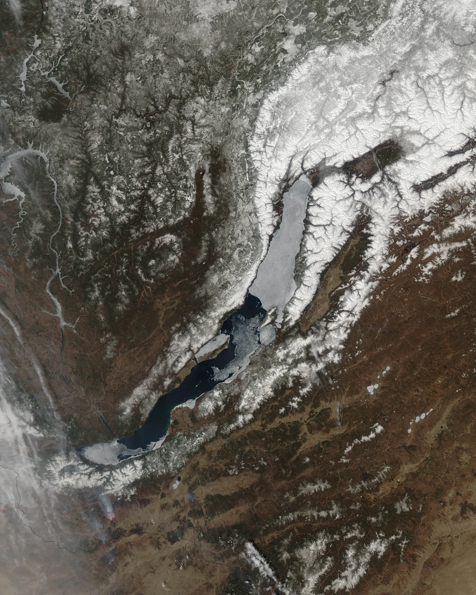
Lake Baikal seen from orbit during spring breakup. White ice covers much of the northern lake while darker open water appears farther south.
NASA Earth Observatory / Aqua MODIS · 4 May 2012

Surface area and water volume

Lake Superior looks enormous. Baikal looks like a narrow blue cut in the land. Which one holds more water? Make a prediction from their shorelines, then reveal the reference volumes.

To understand a lake, first compare its surface. Then look below.

Compare lake area and volume

Start with shorelines at a shared map scale. Reveal the volume, and watch depth change the comparison.

Lake comparisonShared map scale

Which lake holds more water?

Compare the shorelines, make a prediction, then reveal the water volume.

Equal-area outlines at a shared scale, tilted for comparison. Outlines retain their relative geographic size. Select a lake to inspect it.

Lake Superior
82,367 km²surface area
View source ↗

Shapes: Natural Earth 1:10m, generalized. Reference areas and volumes: ILEC World Lake Database, retrieved September 2026; these compiled values are not current water levels. Prism thickness uses volume divided by reference area. Shoreline geometry and reference areas are separate sources, so the prisms are approximate illustrations.

View the data · 5 records
LakeRegionSourceArea (km²)Water volume (km³)Reference source
Lake SuperiorNorth AmericaNatural Earth · 1:10m lake outlines8236712221https://wldb.ilec.or.jp/Lake/NAM-04
Lake VictoriaEast AfricaNatural Earth · 1:10m lake outlines688002750https://wldb.ilec.or.jp/Lake/AFR-05
Lake BaikalSiberiaNatural Earth · 1:10m lake outlines3150023000https://wldb.ilec.or.jp/Lake/ASI-27
Lake TanganyikaEast AfricaNatural Earth · 1:10m lake outlines3200017800https://wldb.ilec.or.jp/Lake/AFR-06
Lake TiticacaAndesNatural Earth · 1:10m lake outlines8372893https://wldb.ilec.or.jp/Lake/SAM-04
5 matches · Page 1 of 1
Lake Baikal seen from orbit during spring breakup. White ice covers much of the northern lake while darker open water appears farther south.

A surface in transition

Lake Baikal seen from orbit during spring breakup. White ice covers much of the northern lake while darker open water appears farther south. NASA Earth Observatory / Aqua MODIS · 4 May 2012.

Five lake locations

Follow the changing shape of water.

Lake Superior spreads across the map with a shoreline full of changes in direction. From this distance, the broad surface is the first thing you notice. Zoom in, and the edges begin to take over the story.

The outline comes from a generalized global dataset. Small bays and islands are simplified, and the boundary does not represent today’s exact water level.

Source: Natural Earth · lake outlines · 1:10m; Mapzen terrain where shown

Move to East Africa and look at Lake Victoria. Its broad shape is a contrast to the narrow lakes we will visit next.

Let your eye follow the shoreline rather than jumping straight to a number. Geometry offers a different way to compare places, without pretending that a map’s blue area tells us its depth.

Source: Natural Earth · lake outlines · 1:10m; Mapzen terrain where shown

Lake Baikal appears as a long, curved form in Siberia. The map tilts here to bring the surrounding terrain into the experience.

A lake outline shows where land meets water in the source map. It does not show the lakebed. The terrain view and the blue polygon answer different questions.

Source: Natural Earth · lake outlines · 1:10m; Mapzen terrain where shown

Lake Tanganyika draws a slender line through East Africa. Compare its outline with the wider shape of Lake Victoria.

Both are blue on a map. Their shapes ask us to imagine very different distances from shore to shore and along the length of the lake.

Source: Natural Earth · lake outlines · 1:10m; Mapzen terrain where shown

Finish in the Andes at Lake Titicaca. The tilted view places its branching outline within the surrounding relief.

We began by looking at water as a shape. We end by seeing that shape as part of a larger landscape. Zoom out once more, and carry that change in perspective into the next place you explore.

Source: Natural Earth · lake outlines · 1:10m; Mapzen terrain where shown

Explore data · Lake Superior · 1 record
LakeRegionSourceArea (km²)Water volume (km³)Reference source
Lake SuperiorNorth AmericaNatural Earth · 1:10m lake outlines8236712221https://wldb.ilec.or.jp/Lake/NAM-04
1 match · Page 1 of 1

What these measurements leave out

Surface area and water volume produce different rankings. A large shoreline does not necessarily enclose the most water.

The reference values describe area and volume, not current water levels, water quality or habitat. The extruded shapes illustrate mean depth and do not reconstruct lake floors.

Sources and methods

Natural Earth · lakes and reservoirs Five named lake outlines with original geometry retained. The interactive comparison uses local equal-area projections at a shared scale.

Natural Earth · public-domain terms Source polygons may be reused and adapted.

A surface in transition NASA Earth Observatory / Aqua MODIS · 4 May 2012

ILEC · Lake Superior Reference compilation: 82,367 km² surface area; 12,221 km³ water volume. Retrieved 13 September 2026. No photographs or descriptive text reproduced.

ILEC · Lake Victoria Reference compilation: 68,800 km² surface area; 2,750 km³ water volume. Retrieved 13 September 2026. No photographs or descriptive text reproduced.

ILEC · Lake Baikal Reference compilation: 31,500 km² surface area; 23,000 km³ water volume. Retrieved 13 September 2026. No photographs or descriptive text reproduced.

ILEC · Lake Tanganyika Reference compilation: 32,000 km² surface area; 17,800 km³ water volume. Retrieved 13 September 2026. No photographs or descriptive text reproduced.

ILEC · Lake Titicaca Reference compilation: 8,372 km² surface area; 893 km³ water volume. Retrieved 13 September 2026. No photographs or descriptive text reproduced.

How this edition was made Generalized 1:10 million shorelines, not a current water-level survey. Terrain is shown at 1× exaggeration and does not depict lake bathymetry. The comparison uses equal-area outlines at a common scale, tilted for display. Mean-depth prisms use ILEC volume divided by reference area, with depth stretched 450×; these are approximate flat-bottom illustrations, not surveyed lakebeds. ILEC values are historical reference compilations, not current water-level measurements.

Data retrieved 2026-09-13. Native maps and original narrative by Atlas Storymaps. Source data: Natural Earth + ILEC. Natural Earth and USGS-produced source data are public domain. Basemap and terrain providers are credited on each map.
Every place has a story.

NASA Earth Observatory / Aqua MODIS · 4 May 2012

Sources & data editions

Inland worlds · source data · Natural Earth + ILEC · Edition 1

Published 13 September 2026 · Fixed edition

Create with Atlas Storymaps